You approach El Chalten down a very long (80+km) and wide (30+ km in places) valley surrounded by mountain ranges. And on a clear day like we had, you can see Mt Fitz Roy from an hour away (and, as we discovered on our return trip, from 2 hours away in the right place).
 |
| Getting close to Fitz Roy, elevation 3359m |
El Chalten is a tiny climber town, but is oddly charming. You get a free 5 minute overview (and map) of hikes in the park at the ranger station on your way into town, which is really helpful. They are slowly building more hotels and services in anticipation on increased tourist traffic. But there's still only 1 ATM in the bus station that works 1/2 the time, internet service is spotty at best, and groceries are available but minimal and expensive.
 |
| Main Street El Chalten |

You get a sweet view of Mt. Fitz Roy from downtown (above). That was our destination for the following day (in particular because the next valley over - home of the Cerro Torre hike - was inundated with clouds and wind when we arrived while Fitz Roy remained oddly cloud-free).
You can hike directly from El Chalten to the viewpoint on Fitz Roy, but it's a long and not totally interesting uphill slog all the way - and once you reach the top, you have to retrace your footsteps back to town (unless you loop over to the Cerro Torre trail & create a huge circle route, which is far too long for most to do in a day). Instead, we caught a shuttle to the far side of Fitz Roy so we could do a one way trip up a fairly flat trail to the Fitz Roy viewpoint, then continue on to town via the usual route - no scenery repeats, and not quite as much elevation gain.

By 9am we had ridden a dirt road for nearly an hour and were on the far side of the mountain. Our route would take us up the forested valley (above), around the left side of the peaks, following the Rio Blanco (White River).

Sarah was happy to be on the trail again.

Chad was also looking forward to an uncharacteristically sunny and calm day hike in Patagonia.

Oh, and so were three dozen of our closest friends... sigh.

Well, things will be less crowded on the trail I'm sure. After all, it's still shoulder season.

Umm, apparently not. What's with all of the clumped together tour groups? And why do they all need a guide when the path is as obvious, well-marked and well-graded as the Stanley Park Seawall?

Fortunately our W Route hiking skills quickly propelled us past the bunched up tour groups, and we got to enjoy some very luxurious trails. The trail was far, FAR better maintained than the W Route, and it cost us exactly $0 in fees to enter the park and do the hike. Score one for Argentina.

A lovely hanging glacier was on display as we made our way up the valley (heading to the left and looping around before getting closer to Fitz Roy).


As long as the weather stays clear, you always know where your destination is!

Looking back towards the start of the hike.

That's where we were headed. The trail gets a lot steeper (and more exposed to the sun) as it heads up to the ridge - you can see the trail on the left side.

A quick riverbed crossing before starting the climb.

At this point I felt a bit bad for our W Trek friends Oliver and Roz. They had done this same hike less than 2 weeks before, and the weather was SO BAD that they 1) could not see Mt. Fitz Roy the whole time, and 2) despite being good hikers, could not complete this part of the hike because of the weather.

We were lucky enough to have a cloudless, nearly-windless day, where one could sit on a boulder at the top of the hike indefinitely with only shorts and a T-shirt. Stunning.

Top of the hike is a bowl (wide angle shot above) featuring a snow-covered frozen lake at the bottom.


The boulder-top view towards El Chalten and the second half of the hike.

Sarah strides to the top (after a hot, steep scramble up some loose trail surfaces). [Sarah: 'strides' might be a bit of an exaggeration. Despite all my W Route training, the last scramble to the top was rough for me.]

Arrgh! Is that all you have for me, mountain?

Actually, as I look to the right side of Fitz Roy, I note there's a bluff (the top one at the extreme right edge of the above photo). Hmm.

Channeling my inner Shaun Frost, I looked around some more and noticed that after a couple of rolling dips you can walk a largely snow-free route (on the right side of the above photo) up to a ridge. And it looks like the rocky top of the ridge goes all the way to the bluff (just to the left of the big snow slope). Others have walked similar routes, because I can see footprints and ski/snowboard trails in the snow slope. It's sunny, I wouldn't have any snow threatening me from above, the brief sections of snow I'd cross are all at the bottom, are thin, wet and have been crossed many times before. It looks like I could get up there safely!
With Sarah's permission, I thought I'd give it a shot. [Sarah: permission was granted with two caveats: that he be careful, and that I didn't have to go with him!]

OK, this is a deceptive photo - the trail was not actually this steep-looking (or I wouldn't have risked it). This was the longest stretch of snow, it was at the bottom and was well-packed.

The rock changed from somewhat loose granite blocks at the bottom to very loose small plates of red rock at about the halfway point. Fortunately I was able to pick up a faint, unmarked trail here and there that made the going easier. But it still took some work. Destination was the top of the bluff immediately to the right of Fitz Roy (above).

Nearer the top, some scrambling over very large blocks of stone was required. Fun!

Then a final scramble up a channel in the bluff.

Followed by the trickiest self-timed photo ever at the top! (Only 12 seconds to get from camera my seat on the peak.)

I turned back at this point because I'd reached my destination, because Sarah was waiting, and because the scramble got much hairier after this point and I'd never do it without a partner (see above photo).

Edge of the bluff overlooking the bowl below.

Decent Fitz Roy view from up here.

The top of the central sandy-looking section is the end of the official hike to Fitz Roy (where Sarah was waiting).
Here's a 360 panorama movie from the top of the bluff. (Shaky camera work, but that's what happens when you are standing on a narrow, uneven surface surrounded by cliffs.)

In the meantime, Sarah was channeling her inner yogi and doing some mountaintop meditation/yoga.

After getting a bit off-track on the way down the mostly-featureless scree slopes of my impromptu scramble (including some alarming steepness and looseness that necessitated hasty backtracking at one point) I made it back to Sarah, who was glad to find me in one piece and to get back on the trail.

Sarah has come a long way with steep and/or loose trails. She worked hard getting down the steep slope to the valley trail again - well done!

A mohawk of rocky pillars on the shoulder of Fitz Roy.

A real read-headed woodpecker! They are pretty common in this area.
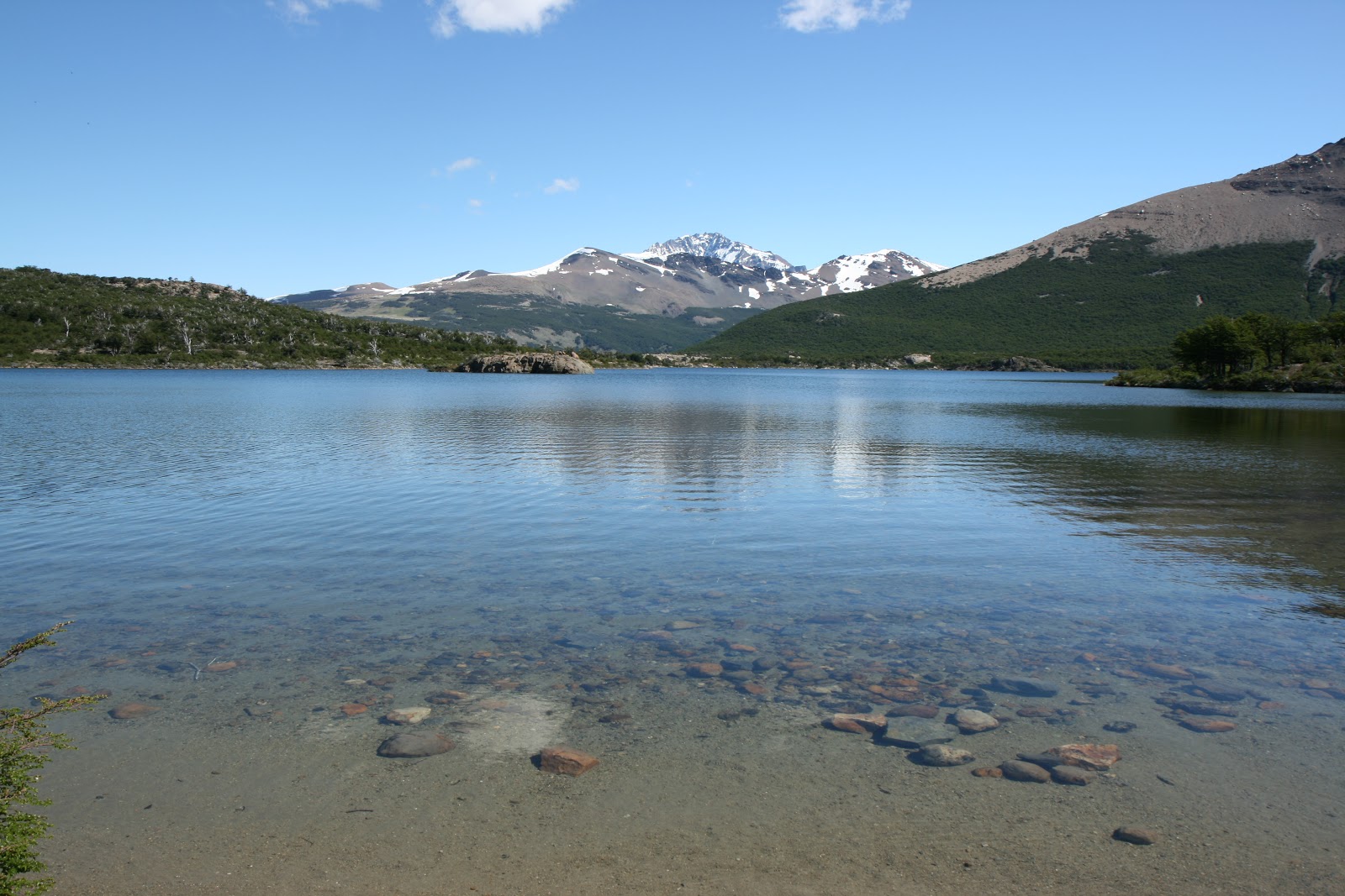
We had the option of going past a viewpoint or a lake on the trail back to El Chalten. We wisely chose the lake trail - the gorgeous clear water would have been grand for swimming, though we decided to press on instead of swim.


Near the end of the trail, you get nice views from a bluff overlooking El Chalten, both up the valley we had driven through this morning (above)...

...and of El Chalten itself.

Sarah at the start (in our case, finish) line! 18 km according to the internet (sans Chad's scramble), but I suspect that's on the low side. Our dogs were barking.

Sarah wasn't pleased with walking another kilometre or more to our room in boots. [Sarah: not pictured - the part where Chad literally pushed me up the street as my feet were screaming in my boots!]

At least we continued to see nice views on the walk to our room. What ridiculously good weather, totally uncharacteristic for Patagonia.

We decided to reward ourselves with - you guessed it - dinner at a brewpub. Yes, even El Chalten has jumped on the craft beer bandwagon. This place looked very cozy and decently authentic.

The service was good, as was the food. I had the local specialty: locro, a lamb stew.

But the beer? We were learning - samples first. The verdict?

Well, here's what I ended up drinking. (To paraphrase Monty Python, "these are not beers for drinking, these are beers for laying down and avoiding," at least until the quality rises past "undrinkable." If you think I'm just being a beer snob, ask Sarah what she thought of the samples.)
But not even craft beer failure could spoil such an idyllic day of hiking. Truly a day to savour.
No comments:
Post a Comment